This Blog collect many basic info about earth from many resources, scientific report, or everything that conected to geology, oil, and gas.
From Public Lampung Goverment report or many scientific report and text book to learn about Lampung, earth and geology.
All material viewed just only the material that has been published to public.
Collected by Harlin Pasili Ansori ST.(Eng.Geol)
Indonesia from Bali "World Geothermal Congress" (April 25th-30th 2010)
The Fourth World GeothermalCongress in Bali as an opportunity for the world to know Indonesian Policy on the price of Indonesia’s geothermal electricity (Indonesian was represented by INAGA or The Indonesian Geothermal Association). The five days congress attended by 2500 delegates from 80 countries included Iceland which 95% energy suplly for this country from Geothermal. Indonesia is the fourth position in the world of Geothermal after Philippines, USA and Mexico (in Producer of geothermal energy mix right now the highest held by Iceland.The Indonesian regulation form from Minister of Energy and Mineral Resources no. 32 dated December 4th 2009. At this Congress Indonesia launched 3997 Mw from 10.000 Mw (phase II) in 44 new areas which are planned to be all operated at 2014.
The Potentials of Geothermal Energy in Indonesia are about 27.000 Mw (about 40 percent of world potentials) but the development of geothermal power plant only reach 4 percent from Indonesian potentials.
Government of Indonesian it self has been serious in developing this part. Many number of regulation has issued :
Law no. 27 of 2003
Government Regulation no.59 2007
Presidential Regulation no.5 of 2006
Standart price issue EMR Minister regulation no.14 of 2008 and no.5 of 2009
In fact the development of 3977 Mw project will need US$ 13 Billion investation fund. The geothermal at least US$90 per ton if geothermal wants to compete with coal.
The Benefit of geothermal resources for Indonesia are :
40 % of Geothermal of the world in Indonesia (WGC sources)
Free form oil/fossil energyprice fluctuation.
Weather, transportation and loading station doesnot have many effect in the geothermal operation.
It doesnot need vast land area.
Hight dependable.
Hight efficient.
Environtment friendly.
Renewable energy.
Conservation of fossil fuel.
Closed Mining.
Friendly with forest.
In Lampung Geothermal Projects as Power Plant has been exploited in Rajabasa (2x110 Mw) and Ulubelu 3&4 (2x55 Mw). The Geothermal work area to be tender at 2010 in Gn. Rajabasa South Lampung about 91 Mw (in 19520 Ha) and Suoh Skincau West Lampung about 230 Mw (in 33333 Ha). In Indonesia the biggest reserve possible for tender status, Dec 09 is on Liki Pinangawan Muaralaboh (South Solok) about 400 Mw in 62300 Ha (in Phase II by PT. Supreme energy). Last Indonesia target in 2025 is to prodece 9500 Mw Geothermal electricity.
Buying Price of Geothermal Electricity 110 Mw Capacity
(translated as the original text from Selebrigas article in Gas News Magazine Majalah Berita Gas, PT PGN Tbk. November-Desember Edition, 2009) Luna Maya, Gas Bumi Memecahkan Persoalan Lingkungan (dikutip sebagaimana aslinya artikel SELEBRIGAS dari Majalah Berita Gas, PT PGN Tbk. Edisi November-Desember, 2009)
For this advertising model star, the meaning of New-year (2009-2010) she did not spend in glamour party but by imagined how to achieve better achievement in the next year. As a celebrity, this beauty girl which born on august 26th 1983 right now in top level career.
Even in tired condition and very sleepy, Luna still acted as professional. When in front of the camera, her face sinny and ready to action. “what ever my body condition, work time must be a work time,” said this 174 cm body tall and weight about 54 kg.
Conversating about dream target, being the woman which is famous by her creation is the biggest dream of Luna this time. To achieve her dream, she has a big plan in behind the screen. “I’ve began to think what I want to do next year, if I can not exist in entertainment, people still want to know Luna trough my creation". One of it probably work behind the screen. Hopely it can be realizing next year. When she told about her child age story, she took silent for a while. This condition acceptable because she lost her father when she was 12 years old. Lost her hero character, put little Luna became strength kid. When she has a problem, she intend to solve it by herself. Because of Her strength and brave, she went to Jakarta at 16 years old, participated in a teenage magazine cover competition. “”Live dependselfable creates a strength character and thought in every condition. If I can not defend my self and responsible, who will do it? I’ve try not to become a load for my family, event I can not release myconnection from them. The point is I must success and try still dependselfable in my life,” said this Denpasar girl.
When asked about Earth Gas as an alternative energy, Luna wished the earth gas consumption can reduce any environmental problem, such as glass house effect problem, acid rain, smog, solid contaminant, and water pollution. According to Luna, earth gas become an important of energy resources from other energy resources. It causing earth gas become an important fuel for electricity generator., and basically earth gas produce electricity with competitive price, said Luna when she ended the conversation.
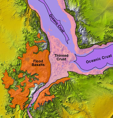
African is one of continent which has been rifting apart until now. Each mean like asingle layer this plate had begun breaking apart since it formed after GondwanaLand. The Rift appears on East, Specifically North East side at this Continent. It formed by a normal fault cracking the east side and made a basin at the beginning. This happening until this present day which modern geologist can record data and studyng this fenomenon.The Geologist are still debating and argue about how this rifting happen. The study about this Rifting and the tectonic forces in this area can be found in James Wood and Alex Guth study in Kenya, and Furman et.al 2004 about System (EARS) Plume Structure: Insights from Quaternary Mafic Lavas of Turkana, Kenya. The two new Continent by Geologist was named Somalian Plate(Little continent) and The Large one called Nubian Plate. This Plates moveaway each other.
The African Rift System
The system of this rifting still debating today, but this Description from James Wood study about this system :
1.The OldAfar (Ethopian Rift)
2.the West Albertian Rift (including EastAfricanGreatLake)
3.Eastern called Kenya Rift (first study in early 1900)
4.Long : ±1000 Km
5.(This system including Red SeaGulf and aden Extension)
6.Fenomenon shown: Graben (like pyramide chair form because of fault), Small Structure shears and extencion.
Even the model of this area rifting are still debated, but the popular model can be described as :
1.Elevated Heat Flow from Mantle (From Astenosphere) is causing two thermal bulges in this north area of the system.
2.when bulges formed, they began stretch and faracture the outer brittle crust t a series normal fault (shown by graben and horst structure in the valley).
3.Three Fracture shown an angular separation about 190º (called triple junction).
The Picture of Rifting from Satelite and Seismic Activity (left)
Picture of P-wave velocities within the Earth's crust and upper mantle along an East-West profile across the Kenya rift (Maguire P.K.H., et.al 994)
The seismic model is approximating an elevation difference about400m, the thickness of the crust at both ends of the profile is approximately the same at about 34km below sea level. A regional gradient needs to be added to the gravity field calculated from the seismic model to agree with the observed (Maguire P.K.H. et.al 1994). This regional is consistent with Ebinger et al.'s (1989).
The Seismic Interpretation in this rifting in Kenya rift from Maguiare et.al 1994 were:
The correlation between seismic velocities in the upper crust and different Precambrian (Archaean and Pan-African Mozambique orogenic belt) crustal packages identified along the profile.
A thickening of the crust beneath both margins of the rift.
The apparent symmetry in crustal thinning mirroring the surface distribution of Tertiary volcanics and sediments, suggesting a pure shear mechanism of crustal extension.
The presence of a wide, anomalously low-velocity (7.6–7.8km s-1) body at the base of the crust identified along the axial line and which it has been argued must include partial melt. This may be continuous with a deep low-velocity zone beneath the rift previously identified from the study of teleseismic residuals.
The presence of an intra-mantle reflector at a depth of approximately 55 km beneath the western margin of the rift.
"Textbook" horst and graben formation (left) compared with actual rift terrain (upper right) and topography (lower right). Notice how the width taken up by the trapezoidal areas undergoing normal faulting and horst and graben formation increases from top to bottom in the left panel. Rifts are considered extensional features (continental plates are pulling apart) and so often display this type of structure.
(sources Geologi.com 2010)
East African rift by Nasa
Commont interest in this rift
Ethiopian and Kenya Rifts:
1.the Eastern and Western branches were developed by the same processes
2.but very different characters:
3.The Eastern Branch : by greater volcanic activity
4.Western Branch : by deeper basins that contain large lakes and lots of sediment.
5.basalt eruptions and active crevice formation shown at the Ethiopian Rift which directly from formation of ocean basins on land. The East African Rift System is an excellent
field laboratory in study a modern actively developing rift system today.
6.some link evolution for paleontology acure in this area because of rifting, surely inviting many Paleontology to study in this place.
The Geothermal Potential of East African from East African Rifting
(Source MC Kritt 1982)
Review by Harlin Pasili ansori 2010
Reference :
Geology.com “East Africa Rift Article” by James wood and Alex Guth 2010
Doug Finlayson 2004, Crustal Architecture of the East African Rift System
P. K. H. Maguire, C. J. Swain, R. Masotti and M. A. Khan
(from Tectonophysics, 1994, vol. 236, pages 217-249)A crustal and uppermost mantle cross-sectional model of the Kenya Rift derived from seismic and gravity data
L. W. Braile, B. Wang, C. R. Daudt, G. R. Keller and J. P. Patel
(from Tectonophysics, 1994, vol. 236, pages 217-249), Modelling the 2-D seismic velocity structure across the Kenya rift
Kenya TANYA FURMAN1,*, JULIA G. BRYCE2, JEFFREY KARSON3 and ANNAMARIA IOTTI4 a 2004East African Rift System (EARS) Plume Structure: Insights from Quaternary Mafic Lavas of Turkana,
San Andreas Fault has Crossing California about 1100 Long. The Fault is a boundary of North American and Pacific Lithosferic Fault. This Fault is the longest fault in this area.The west side plate moves to the north direction , and causing earthquakes when it moved. It has brought many different sets of rocks to face each other across the fault trace. The forces associated with the fault causing mountains orogenesa (push up land becomed a Mountain) in some places and stretched apart large basins in others side (see Pic. 1).
Pic. 1 Movement Force of Fault (Illustrated by Harlin P. Ansori)
The first Professor who detected this fault is Andrew Lawson. He named the fault same as the name of South California Area (Pic 2 Map and Landsat of The Area Source Sanandreasfault.org).
Pic 2 Map and Landsat of The Area Source Sanandreasfault.org 2010
I Create Earth with Strong Mountains with them, so This Whole Earth moves with them. And I Create many wide lines so they (human) can read their direction/guidance.
( Source: God The Al-Mighty Allah, in Qoran Al-Hakeem letter number 21 in verses 31)
Refrerences:
Al-Qoran Al Hakeem الْقُرْآنِ الْحَكِيمِ
Geology.com 2010
Sanandreasfault.org 2010
Wikipedia 2010.com
David K Lynch, Field Guide to San Andreas Fault, 2010.
Geology is the study of the Earth, the materials of which it is made, the structure of those materials, and the processes acting upon them. Some of them include material organism which have inhabited our planet. The important to study in geology must followed the latest news about this teory of geology science because the study of structures, materials, processes, organisme, materials, and tectonics have changed over time following the developing of the electronical instrumental for collecting earth data (which mean hitech-instumental) and hitech modeling researches in laboratory.
Geologist Works
A Geologists learns and researchs to understand the history of our planet Earth (Geo). The better they can understand Earth’s history the better they can foresee how events and processes of the past might influence the future (The past is the key to the future Earth). In word in geologic law “The Present is the key to the past” .Here are some examples:
Geologists study earth processes: Many processes such as orogeneis (mountain forming process such collision and subduction which put up plate higher and form mountain row), landslides (land movement), earthquakes, floods and volcanic eruptions can be hazardous and harm people. Geologists try to understand these processes well enough to avoid building important structures where they might be damaged including classifying zone of disaster to make amap guide of disaster zone. It will help many City and Area Planning for the future.
Geologists study earth materials: earth materials are used by people every day. They use oil , metals from mines, and water from underground. Geologists studies to locate rocks that contain important metals, plan the mines that produce them and Which methods more economic in used to remove the metals from the rocks. Of course this work including how to locate and produce oil, natural gas and ground water.
Geologists study earth history:
Study Earth History to learn and form a perfect teory of many schene structure which present shows us. Ofcourse the teory must proved with hight technology modeling to learned and proved the teory of the geology history. Many model such as real miniature modeling (including scalar component) and digital 3d modeling with data parameter helps to form the global of earth history, which is formed by many geology regional phenomenon. Today geologist are concerned about climate change. Many geologists are working to learn about the past climates of earth and how they have changed across time which is connected with the earth outer core movement. This information is valuable to understand how our current climate is changing and what the results might be. Geology as a Career:
To be a Geologist is a very interesting and rewarding career. Of course need four year training tobe a four-year college degree in geology. Pre-college students who are interested in becoming geologists should take a full curriculum of college preparatory courses, especially those in math, science, and writing. Courses related to computers, geography and communication are also valuable knowledge to be collected. There are variety work and project need geologist, include: government planning agencies, natural resource companies, environmental consulting companies, government resources administration, non-profit organizations, and universities. For Geologists do a field work only part of the time after field the data and sample will be processed in laboratories, classrooms or offices. All geologists reports, do calculations, technic modeling and use computers.
Although a bachelor's degree is required for entry level employment, many geologists earn master's and/or doctorate degrees to take a speciallity in geology science.A higher level of training, often in a geology specialty area such as paleontology, mineralogy, hydrology or volcanology. Advanced degrees will often qualify to be the geologist for supervisory positions, research assignments or teaching positions at the university level.
opportunities for geologists are very good if they are willing to move to a location where work is available.
Salary of Geologist
In Present day, Salary of geologist have recently ranged from $50,000 to $100,000 per year according to their experiences.
You Become a Geologist
If you are a pre-college student who’s willing to become a geologist, can prepare to become a geologist by doing well in all of your courses. Especially earth science and training is important, but other disciplines such as math, writing, language are used by every geologist during they everyday work.
Get in touch with the geology department, let them know you are interested and make arrangements to visit the campus. Don't be hesitant. Good schools and professors want to be contacted by interested students.
One of Oldest Geology Campus in Indonesia is Geology Departement in ITB (Institute Technology of Bandung / Bandung Institute of Technology) in Bandung City, West Java . The Study Geology Facilities in Bandung such as library, room laboratory, computer laboratory, studio, nature/field laboratory, equipment facility, and include one Indonesian museum of geology. . With Indonesia Island arc as they laboratory, probably you’ll become the next Indonesian International Expert Geologist.
Harlin Pasili Ansori
Sources : Itb.ac.id or departemen Tehnik geologi ITB (Institut Teknologi Bandung) geology.com discovery chanel
September-October 2009 Large Earthquake in Indonesia
Plus Field Important Information Equipment on This Area
1. Large 7,6 SR Earthquake in West Sumatra Province Indonesia
A. News Source from ESDM News
Location:
The Earthquake Disaster in Padang Indonesia at September 29th-30th 2009, has main earthquake 7,6 SR and the next following earthquake in 6,2 SR. As a Fact this earthquake didn't followed by a tsunami (overlarge wave) disaster.
From DESDM Institution announced this earthquake happened because subduction (in area of crash zone from two big plate tectonic) of Indonesian Sea Plate (Australian Plate) under Asian Plate which located along West Coast of Sumatra Island, according USGS it's in subduction zone between Australian Plate and Sunda Plate. (note this Formation of collide is Subduction Form because the two plate which is Sea Plate and Continent Plate, has a Large Differentiation of Density between them. The lower density plate later subducts under the higher density plate).
This Earthquake didnot have ability to produce Tsunami because the epicentre (earthquake source point) deep enought location, and as the result didn't produce Large Power to made a tsunami.
Information from Indonesian Meterolog, Climate and Geophysist Institution (BMKG), this earthquake appeared in afternoon (30/9), at 17:16:09 WIB in 7,6 Scala Richter (SR). Epicentre (earthquke source point) layed on coordinate 0.84 LS - 99.65 BT, 71 Km depth from water sea level, 57 Km far from South West Pariaman, Sumatera Barat. The Second (following) earthquake appear 22 minutes later, on 17:38:52 WIB in 6,2 SR, Epicentre location on 72 LS - 99.94 BT, at 110 Km depth, 22 Km SouthWest Pariaman, Sumatera Barat.
Other Large Earthquke in September - October in Island Arc Java-Sumatra is on Sukabumi South Java and Later in Sunday October 17th 2009 at Ujung Kulon, Sunda Strait. Both of them caused by Tectonic Plate movement.
see more informations about West Padang Earthquake from The Field in: http://www.theage.com.au/world/second-quake-hits-sumatra-as-death-toll-soars-20091001-gd43.html
60 km (35 miles) WNW of Padang, Sumatra, Indonesia 225 km (140 miles) SW of Pekanbaru, Sumatra, Indonesia 470 km (295 miles) SSW of KUALA LUMPUR, Malaysia 975 km (600 miles) NW of JAKARTA, Java, Indonesia
From USGS Report (write as in original text) about Padang Earthquake September 30th 2009
Felt Reports
At least 1100 people were killed, 2181 were injured and thousands are still unaccounted for in the Padang area. More than 2650 buildings have been damaged in the area and landslides have disrupted power and communications. Felt (VII) at Padang. Widely felt throughout Sumatra and Java, Indonesia, Malaysia, Singapore and Thailand. A small local tsunami with wave heights of 27 centimeters (amplitude measured relative to normal sea level) was generated.
Tectonic Summary
The southern Sumatra earthquake of September 30, 2009 occurred as a result of oblique-thrust faulting near the subduction interface plate boundary between the Australian and Sunda plates. At the location of this earthquake, the Australian Plate moves north-northeast with respect to the Sunda plate at a velocity of approximately 60 mm/yr. On the basis of the currently available fault mechanism information and earthquake depth of 80 km, it is likely that this earthquake occurred within the subducting Australian Plate rather than on the plate interface itself. The recent earthquake was deeper than typical subduction thrust earthquakes that generally occur at depths less than 50 km. The subduction zone surrounding the immediate region of this event has not witnessed a megathrust earthquake in the recent past, rupturing last in an earthquake of M 8.5 or larger in 1797. Approximately 350 km to the south, a 250 km section of the plate boundary slipped during an Mw 8.4 earthquake in September 2007, while approximately 300 km to the north, a 350 km section slipped during the Mw 8.7 earthquake of March 2005. In early 2008, the plate boundary updip of today’s earthquake was active in a sequence of Mw 5-6 earthquakes. It is not clear how today’s earthquake is related to the sequence of megathrust subduction zone events on the shallower section of the plate boundary.
2. Important Maps to Equipt if you want to go to PadangEarthquake area in Indonesia
With the exception of public UN sources, reproduction or redistribution of the above text, in whole, part or in any form, requires the prior consent of the original source.
For Fund emergency Disaster conect to UNOCHA.
Your Important maps to equipt in Padang............
1. Map from reliefweb "The Temporary Map about region Damage because disaster in Padang Source Ocha, Reliefweb, and rovicky.wordpress.com and
2. Map from USG Humanitarian Assistance to Indonesia Earthquake, September 30th, 2009
Klick on Image
Small view
3. Indonesia: Population Map – Padang North [with building damages] (as of 01 Oct 2009)
klick on image
4. Potential Building Damage Source(s): - German Aerospace Center (DLR) - International Charter Space and Major Disasters Klick: Potential Buiding Damage
5. Free Bakorsurtanal Earthquake Location Maps (Basic Maps of The Location)
admin blog
is Harlin Pasili Ansori ST.MT.(Groundwater Technic)
both title ST. and MT. from Institute Technic of Bandung (ITB) Indonesia.
a civilian goverment officer of mining and energy resources regional departement in Lampung Province, Indonesia.Asweat hand geologist.