The East African Rift
African is one of continent which has been rifting apart until now. Each mean like asingle layer this plate had begun breaking apart since it formed after
The African Rift System
The system of this rifting still debating today, but this Description from James Wood study about this system :
1. The Old Afar (Ethopian Rift)
2. the West Albertian Rift (including
3. Eastern called Kenya Rift (first study in early 1900)
4. Long : ±1000 Km
5. (This system including
6. Fenomenon shown: Graben (like pyramide chair form because of fault), Small Structure shears and extencion.
Even the model of this area rifting are still debated, but the popular model can be described as :
1. Elevated Heat Flow from Mantle (From Astenosphere) is causing two thermal bulges in this north area of the system.
2. when bulges formed, they began stretch and faracture the outer brittle crust t a series normal fault (shown by graben and horst structure in the valley).
3. Three Fracture shown an angular separation about 190º (called triple junction).

The Picture of Rifting from Satelite and Seismic Activity (left)
(information from
‘Crustal and upper mantle structure of the Kenya Rift’ Tectonophysics
Volume 236, Issues 1-4, Pages 1-483 (30 September 1994).
(pict from Doug. Finleyson 2009)

Picture of Rifting (Tasa Graphic arts 1984)

Picture of P-wave velocities within the Earth's crust and upper mantle along an East-West profile across the
The seismic model is approximating an elevation difference about 400m, the thickness of the crust at both ends of the profile is approximately the same at about 34km below sea level. A regional gradient needs to be added to the gravity field calculated from the seismic model to agree with the observed (Maguire P.K.H. et.al 1994). This regional is consistent with Ebinger et al.'s (1989).
The Seismic Interpretation in this rifting in
- The correlation between seismic velocities in the upper crust and different Precambrian (Archaean and Pan-African Mozambique orogenic belt) crustal packages identified along the profile.
- A thickening of the crust beneath both margins of the rift.
- The apparent symmetry in crustal thinning mirroring the surface distribution of Tertiary volcanics and sediments, suggesting a pure shear mechanism of crustal extension.
- The presence of a wide, anomalously low-velocity (7.6–7.8km s-1) body at the base of the crust identified along the axial line and which it has been argued must include partial melt. This may be continuous with a deep low-velocity zone beneath the rift previously identified from the study of teleseismic residuals.
- The presence of an intra-mantle reflector at a depth of approximately 55 km beneath the western margin of the rift.
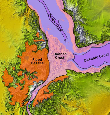
| "Textbook" horst and graben formation (left) compared with actual rift terrain (upper right) and topography (sources Geologi.com 2010)
|


East African rift by Nasa
Commont interest in this rift
Ethiopian and
1. the Eastern and Western branches were developed by the same processes
2. but very different characters:
3. The Eastern Branch : by greater volcanic activity
4. Western Branch : by deeper basins that contain large lakes and lots of sediment.
5. basalt eruptions and active crevice formation shown at the Ethiopian Rift which directly from formation of ocean basins on land. The East African Rift System is an excellent
field laboratory in study a modern actively developing rift system today.
6. some link evolution for paleontology acure in this area because of rifting, surely inviting many Paleontology to study in this place.
http://geology.com/articles/east-africa-rift/figure4-400.jpg
Source Geology.com

The Geothermal Potential of East African from East African Rifting
(Source MC Kritt 1982)
Review by Harlin Pasili ansori 2010
Reference :
Geology.com “East Africa Rift Article” by James wood and Alex Guth 2010
P. K. H. Maguire, C. J. Swain, R. Masotti and M. A. Khan
(from Tectonophysics, 1994, vol. 236, pages 217-249)A crustal and uppermost mantle cross-sectional model of the Kenya Rift derived from seismic and gravity data
L. W. Braile, B. Wang, C. R. Daudt, G. R. Keller and J. P. Patel
(from Tectonophysics, 1994, vol. 236, pages 217-249), Modelling the 2-D seismic velocity structure across the Kenya rift
Kenya TANYA FURMAN1,*, JULIA G. BRYCE2, JEFFREY KARSON3 and ANNAMARIA IOTTI4 a 2004East African Rift System (EARS) Plume Structure: Insights from Quaternary Mafic Lavas of Turkana,
http://blue.utb.edu/paullgj/physci1417/Lectures/Plate_Tectonics.html


Tidak ada komentar:
Posting Komentar